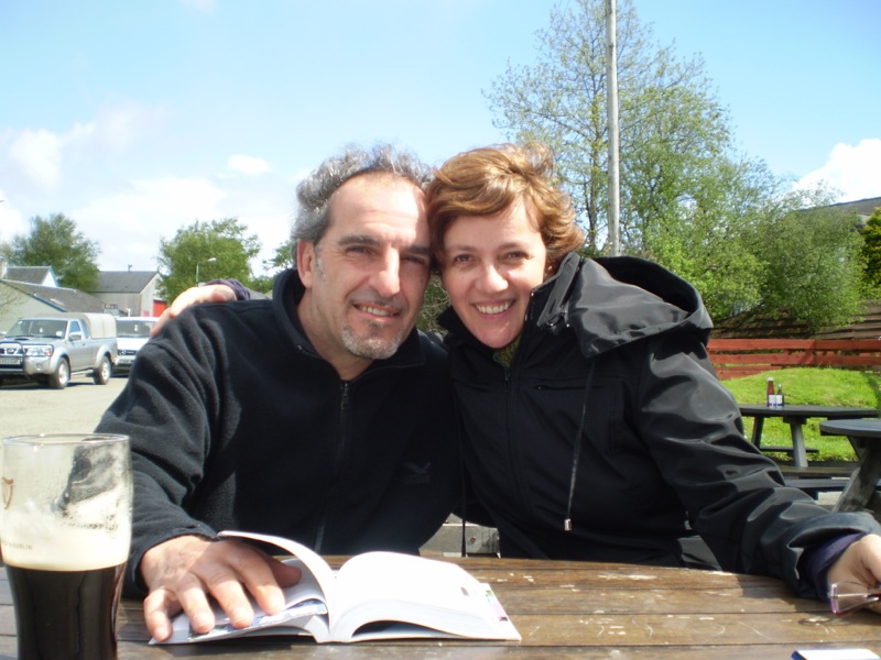
Central America 2008


Viva la vida!

Central America

Central America

Four weeks can be a short period of time when you want to see all Central America, but we decided to try anyway : instead of visiting one country on the whole, we choose two or three notable places for each country and then go for it! Let’s try and see what the road brings to us, being prepared to change itineraries if necessary.

So, once arrived in Guatemala, we headed to Antigua, climb the Pacaya Volcano as any good backpacker do here, and then on to Atitlan Lake for two days. From there back in Guatemala City to take a necessary plane to the north to see the magnificent archeologic site of Tikal.

Then, we went by bus to Belize. Belize is an exception in Central America. It is a country populated by black people , english speaking (it was a United Kingdom’s colony). We went straight to the small island of Caye Caulker to see the big reef (second only to the great Australian one) and we stayed for a while doing snorkeling on the Blue Hole (an incredible circular “hole” 240ft deep and 300ft wide) with the company of BIG bull sharks (i was terryfied , i admit) swimming just a few meters below us.

From Belize City we took a flight to San Salvador (the capital of El Salvador) attracted by the stories of guerrilla we had heard when we were kids. In fact El Salvador is a fantastic country and the stories of danger and murders are exaggerated. Still, San Salvador in some part is really scary and one have to be careful when walking around.

In El Salvador we discovered two nice places : Suchitoto and Juayua. Two simple town full of great people with lots of stories to tell about the dark years of the USA backed atrocity. A history lesson. We went to see the guerrilla camp in the jungle and one of the place – Cinquera – were many unarmed people were massacred by the army looking for “communists”. In fact the communists in El Salvador at those times were very few, the majority of the population was simply tired of being exploited by the rich and the army, too.

After a tour (this time only nature, no history) in the coffee plantations and the waterfalls around Juayua, and a short break in San Salvador we left El Salvador by Bus to Nicaragua, destination Leon.

The history of Leon and Granada (the third and second biggest city in Nicaragua respectively) is the story of two enemy cities, being Leon a “leftist” city and Granada the most conservative place in Nica. Leaving behind the political matters, both town have a charming city centre (Granada almost as polished as any western town) and horrible suburbs, were people live in terrible conditions. The best experience we had here, apart form the cultural things, was the encounter of a Spanish guy (i should say Catalan) Tio Antonio, who had come here for business and ended up founding an association to protect and give jobs to the children of Granada. Take a look at his site, he’s a great person.

From Granada we went on to Isla Ometepe, one of  the world’s biggest lake island, formed by two volcanoes joined by an isthmus, and then back to the border of Costa Rica. In Costarica we visited Tortuguero, one of the most interesting place. It’s a beach were every year hundreds of Giant Green Turtles (250 kg!) come to lay their eggs. We had the opportunity to see them at night actually laying their eggs and then slowly go back to the ocean.

From there by boat we reach Panama Border to go to the fabulous archipelago of Bocas del Toro to have some days of rest, then on to Panama City to see the Panama Canal then at the Airport for the return flight.

It was an amazing journey through many cultures, glimpses of many different landscapes, faces, and places we will never forget.

Viva la Vida!

Look at our:

Map and itinerary

Pictures of Central America


Tanzania 2006


Kilimanjaro and other stories

kenya-tanzania_I_04

Tanzania – Kilimanjaro

Well, after months of training in our mountains (the Alps) we’re ready to face the big mountain: the Kilimanjaro. From our point of view (we’re not mountaineers, only trekkers) it’s a lot. We’ve been preparing this adventure for months, we have choose to do one of the least followed of the 7 routes to Kilimanjaro: the Rongai Route.

It’s a 6 days trek starting from a small village near the Kenya border. Our guide Gabriel is great and so are the guys we hired from the local company  ilMaasai Expeditions (you can’t do this climb alone, by law you have to hire guide and porters). The first three days are quite relaxing, if you’re at least a bit fit. After 4000m /13100 ft of altitude, things are different, the nights are cold, and there’s only a tent for shelter. There’s nothing technical about this climb, not even ropes or crampons, it’s just very long, we’ve walked 6-8 hour a day to get to the last camp at 4800m. / 15738ft. for the last night before the ascent to the crater.

Then, from there, we started at midnight for the serious day: it’s about 1100mt / 3280ft ascent to the top of  Kili, then a 2000mt / 6500 ft. descent di Horombo Hut all in one day (it’s about 14 hours). The ascent seems infinite, it’s bitterly cold (to the top there were -20 celsius) , but in six hours we finally got to the top, and man, i cannot describe what we saw from there, the dawn from the crater is magical, although you can only stay there for a few minutes, it’s too cold, and so we left that fantastic vision behind and started descending fast.

A word about Porters

It’s been a beautiful adventure, thanks to the guys who brought us there, carrying everything including water up there. They deserve a better pay, some of them weren’t wearing  proper clothes or shoes for that altitude and coldness, so if you go there, please bring with you some extra jackets or boots (something you don’t use anymore). You can donate it to this association www.mountainexplorers.org. They volunteer on raising funds and clothes to ease the job of this guys that carry 20 kilos of gear or more somtimes for a dollar a day.

After Kili, we went to visit the National Parks of Tanzania : Tarangire, Lake Manyara, Ngorongoro, Serengeti. The pictures explain better than words the magnificent things we’ve seen, these are really the last wild areas were you can see planet earth as it would probably looked thousands of years ago.

Then we left the organized tour and proceeded from Mwanza on the Victoria Lake by bus toward south to Shinyanga and then east by train (a terrible train!) to Kigoma on Lake Tanganica. In Kigoma we finally found the real Africa: in town there was only another white person except us. Our intention was to go visit the Mahale Mountains National Park, which is one of the last reserve where you can see the Chimpanzee in the wild. But we wanted to go by boat and not by plane (far too expensive), but we made some miscalculation on the time we needed, so we had to change our minds and head to Zanzibar for the last part of our trip : relax!

In Zanzibar we stayed in a beautiful bungalows on the south coast (the least crowded) for 4 days, then we went to Stone Town for a brief tour and finally back home…

Africa is a special, special place. It catches your soul like no other place… so as you will see in the next year we had to return to see our friends there  and those unbelievable skies, African Skies

Here’s our:

Map and itinerary

Pictures of Tanzania

Map and itinerary – Central America


map_of_central-america

map_of_guatemala

26 august 2008 – Flight Iberia – Turin – Madrid – Guatemala City – by bus to Antigua

27 august 2008 – around Antigua

28 august 2008 – trekking on Pacaya volcano

29 august 2008 – from Antigua to Atitlan lake – Panajachel – around Atitlan lake

30 august 2008 – from Panajachel to Guatemala City by bus – to Flores by plane

31 august 2008 – from Flores to Tikal by bus – around Tikal – back to Flores

map_of_belize

1 september 2008 – from Flores to Belize City by bus – to Caye Caluker island by boat

2 september 2008 – snorkelling tour around Caye Caulker and San Pedro island by boat

3 september 2008 – Blue Hole tour by boat

4 september 2008 – from Caye Caulker to Belize City by boat – to San Salvador – El Salvador – by plane

map_of_el-salvador

5 september 2008 – from San Salvador to Suchitoto by bus – around Suchitoto

6 september 2008 – trekking around Suchitoto – National Park – guerrilla road – Cinquera

7 september 2008 – around Suchitoto

8 september 2008 – from Suchitoto to Ruta de las Flores by car: Sonsonate,  Apaneca, Ataco, Juayua

9 september 2008 – trekking around Juayua – coffe plantation – forest – waterfalls

10 september 2008 – from Juayua to Sonsonate – San Salvador by bus

map_of_honduras

11 september 2008 - from San Salvador to Leon, Nicaragua crossing Honduras

map_of_nicaragua

12 september 2008 – around Leon -in the afternoon from Leon to Granada by bus

13 september 2008 – around Granada

14 september 2008 – around Granada – Las Isletas tour by boat

15 september 2008 – from Granada to Rivas – San Jorge by bus – from San Jorge to Ometepe Island by boat – around Ometepe by bus

16 september 2008 – trekking around Ometepe – forest and waterfalls

map_of_costa-rica

17 september 2008 – from Ometepe to San Jorge by boat – from San Jorge to Rivas – Penas Plancas (Costarica border) by car – from border to San Josè by bus

18 september 2008 – from San Josè to Barra del Colorado by plane – from Tortuguero by boat – Turtles tour at night (giant green turtles)

19 september 2008 – around National Park by boat and trekking

20 september 2008 – from Tortuguero to Moin by boat – to Limon – Cahuita by bus

21 september 2008 – around Cahuita

22 september 2008 – from Cahuita to Bri Bri, Puerto Viejo, Sixaola – Panama border by bus – to Almirante by taxi – to Bocas del Toro by boat

23 september 2008 - around Bocas del Toro – Bocas del Drago – Playa de Las Estrellas

24 september 2008 – around Bocas del Toro – Coral Cay – Playas Ranas Rojas – Hospedaje Bay

25 september 2008 – around Bocas del Toro – to Isla Bastimentos by boat – trekking around Isla Bastimentos

map_of_panama

26 september 2008 – from Bocas del Toro to Panama City by plane – around Panama CIty

27 september 2008 – around Panama City – flight in the evening to Madrid

28 september 2008 - From Madrid to Turin, Italy

Pictures – Central America

Central America – notes from the journey

Bolivia 2002


Following Butch Cassidy

and the Sundance Kid footsteps

Bolivia

Bolivia . border

For our next destination after Indonesia, in 2002 we decided to go on the other side of the planet, in South America. Having realized how big it is, we decided to visit Bolivia and Peru , roughly in the center of the continent, so that we could have a glimpse of two countries, the Andes, the Pacific Ocean, some of the best archeological wonders, and some strange animals.

For the first half  of the trip, we got to Lima first, then we flew straight to La Paz, (which IMHO is one of the most beautiful city in the world). From there we explored by bus, trucks and jeeps the andean region (including the Salar of Uyuni, an incredible flat entirely made of pure salt as big as a staggering 4000 square miles) towards the border of Chile. Then back to La Paz, from where we headed towards Peru (read the next chapter)

The people here have thick, sun tanned skin, the mix of Indigenous and Spanish origins are well visible in the eyes and the amazing black hair they have. There is a feeling of  fatalism everywhere, as if the 500 hundred years of Spanish domination had destroyed the remains of the proud old Incas, but things are changing in the last years, and a new national pride is taking place, especially since Evo Morales (of indigenous origin) was elected Head of State.

It’s hard to describe of beautiful these places are, but we can recommend it to anyone is interested in vast plain, endless horizons and sleepy villages in the middle of nowhere. Also, don’t forget to spend some time in La Paz, and if you go there, make sure to do the road from El Alto to the capital on a clear (maybe freezing) starry night. Then stop by the side of the road, get out of the car and turn the engine off for a while. Look down toward the city, you will not be able to distinguish the stars from the city lights. It’s awesome!

Check out our:

Map and itinerary

Pictures of Bolivia

© 2003 - 2012 Aguaplano Suffusion theme by Sayontan Sinha
Stop SOPA